
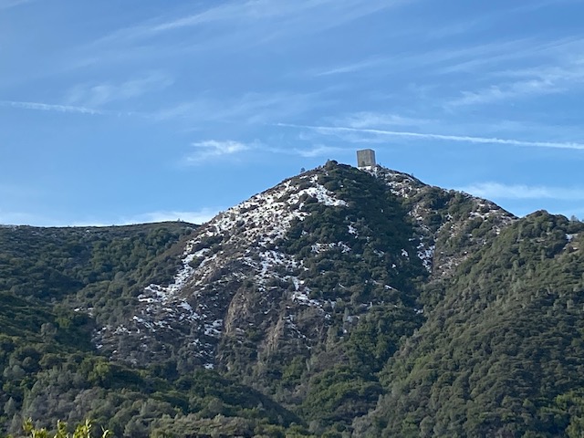
If you aren’t familiar with Mount Umunhum, well, you'll probably learn a bit about it here! It is the fourth highest peak in the Santa
Cruz mountains, at an elevation of 3489 feet at its highest point. Mount Umunhum
has an old radar at the top of it called “The Cube” or “The Box” and can be
recognized by the characteristic shape of this building from across the Silicon
Valley.
We were very excited to learn that during our latest rain
storm in San Jose, Mt. Um received some snow! The roads up to the top were
closed however, starting on the day that snowfall occurred. The following morning, we learned that it was possible to drive up
to the Bald Mountain parking area and hike up to the top. The hike is a fairly
long one and we did not attempt it. It was 3.7 miles in each
direction. However, we wanted to experience snow and were able to do that by
hiking just about 3 miles roundtrip.
We parked with a lot of difficulty at the parking lot. It was full
with all the enthusiastic South Bay residents eager to see snow. After a
bit of patience and luck, we got a parking spot and started off. We were fortunate to
see a lot of snow on the sides of the Bald Mountain trail.
There were a few clearings where we were able to play in the
snow. My daughter was over the moon since she’s been wanting to see snow for a
very long time. We had fun throwing snowballs at one another. A little further
took us to a picturesque bridge that was covered in snow. We could see the
fresh spring water flowing in the creek below. We finally reached a beautiful
view point about 1.5 miles in, and were enthralled by the beauty in all
directions. Mt. Um was towering over us streaked in snow and had a very
majestic appearance.
On our way back, we built a snowman “Snowy” and this was the
highlight of our hike. We learned from the signpost at Mt Um that the origin of
many creeks in our area is from this peak. The Los Gatos Creek, Rincon Creek
and Guadalupe Creek all begin here. The creeks join other waterways from the Santa
Cruz mountains and together form the Guadalupe River which flows through
downtown San Jose. All of the surrounding land is called the Guadalupe Watershed.
We would love to return and either drive up to the top of
Mount Umunhum or hike there one day. For now, we hold our one-of-a-kind
experience of a snow hike close to our hearts.


No comments:
Post a Comment